The Stages of the Cammino

Route map
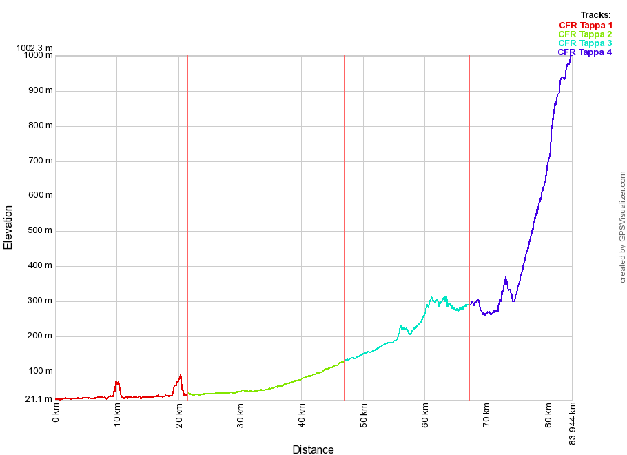
Elevation profile

Compare the four stages
Stage
- Starting point
- Arrivo
- Municipalities
- Technical details
Lenght
Stage 2
- Vicenza
- Marano Vicentino
- Caldogno
Dueville
Villaverla
Malo
Marano Vicentino - Easy. Completely flat.
25.3 Km
Stage 3
- Marano Vicentino
- Velo d’Astico
- Marano Vicentino
Schio
Santorso
Piovene Rocchette
Velo d’Astico - Easy. Some climbs and descents.
20.3 Km
Stage 4
- Velo d’Astico
- Tonezza del Cimone
- Velo d’Astico
Arsiero
Tonezza del Cimone - Hard. 700m ellevation towards the end.
16.7 Km
GPS tracks to navigate and view in Google Earth
DISCLAIMER
GPS tracks, maps and route descriptions may contain errors due to the instrumentation used. Route conditions may change over time due to overgrowth, snowfalls, subsidence, roadworks, etc. All information contained in maps, GPS tracks, and roadbooks should be taken as approximate, as for any topographic map. Great care should especially be taken with tracks in bad weather or when visibilty is reduced. Routes may also pass through private property or potentially dangerous stretches of road, where traffic is heavy or there may be a danger of accidents happening (exposed sections in the mountains or canals with no barrier protection, etc.). The Associazione Cammini Veneti urges those using the tracks, maps and roadbooks to use the information carefully and not to be over-reliant on GPS tools. The Associazione Cammini Veneti declines all responsibility with regard to the use of GPS tracks downloaded from this site.
GPS tracks last updated: May 2021
Always check you have the most recently updated GPS tracks before setting out on the Cammino Fogazzaro Roi.


